VIMSVIMS

Fire compartments, ATEX zones and safety plans: how to build a coherent site map

A plant safety map is a structured floor plan linking hazards, evacuation routes, emergency equipment, energy isolation points and chemical storage locations. Fire compartments limit the spread of fire, while ATEX zones identify places where explosive atmospheres may occur. These are different classifications: their boundaries may overlap, but they are not interchangeable. A digital map makes approved information accessible; it does not replace competent engineering assessment.

One floor plan can support EHS, fire protection, maintenance, quality and contractors. The essentials are current data, readable layers and approved sources — not coloured areas drawn by guesswork.

  • Fire compartments
  • ATEX
  • Evacuation
  • LOTO
  • QR/NFC

Published: 2026-10-11 · Updated: 2026-10-11 · 12 min read · Varilo deployment team

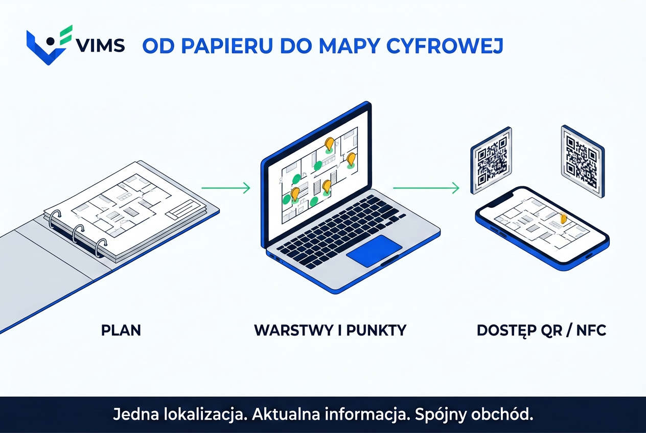
VIMS conceptual illustration: paper site plan becoming a digital safety map with location points and QR/NFC access

1. Information plan, evacuation plan and hazard map: different purposes

An information plan helps people find a hall, entrance or technical room. An evacuation plan presents information needed to leave the building. A hazard map covers areas such as Ex zones, chemicals and energy sources. Where required in Poland, the fire safety instruction (IBP) is broader documentation combining fire safety conditions, procedures and graphic plans.

Not every layer belongs in every view. Workers need clear exits, maintenance technicians need the correct isolation point, and inspectors need equipment and defect locations. Too much information makes even an accurate plan difficult to use.

Digital maps do not replace required documents, physical signs or plans prepared by competent professionals. The illustrations in this guide carry Polish labels and are educational examples, not designs for a particular site. Polish requirements described below must not be assumed to apply in other jurisdictions.
2. Fire compartments and evacuation routes

A fire compartment is a building or part of it separated from other buildings or spaces by fire-resisting separation elements, or the required open separation area under applicable building rules. Its boundary is not simply a department or production-line boundary. It comes from technical documentation and the actual fire protection arrangements.

Distinguish compartment boundaries, fire walls and closures, escape routes and exits, extinguishers, hydrants, manual fire alarm call points, fire-service electrical isolation controls, assembly points and responder access. A call point activates an alarm; an electrical isolation control has a different function and a scope defined by the design.

R, E and I refer to load-bearing capacity, integrity and insulation; the number gives time in minutes. Not every element is classified REI: its designation depends on the element and design requirements. Fire load density also requires material data and an appropriate calculation method, not a visual estimate.

The drawn escape route must match an accessible route on site, without obstructed doors, stored pallets or arrows through solid walls. ISO 7010 signs help identify safety information; a sign library alone does not certify an entire plan.

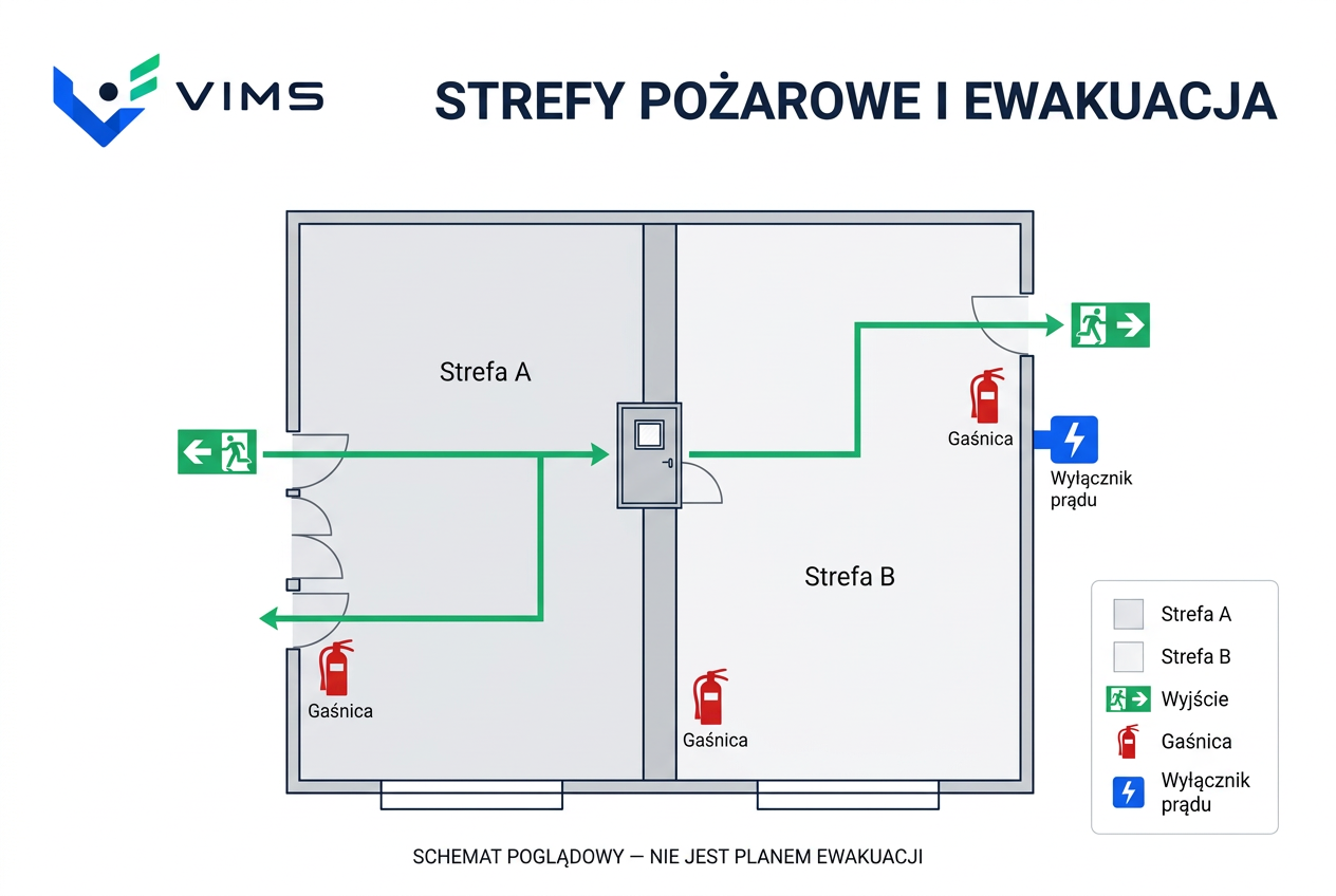
VIMS illustrative floor plan: two fire compartments, separating wall, evacuation routes, extinguishers and electrical isolation point
Educational illustration with Polish labels; not a certified evacuation plan or building design.

3. ATEX zones 0, 1, 2 and 20, 21, 22: definitions

An explosive atmosphere is a mixture with air, under atmospheric conditions, of flammable substances as gases, vapours, mists or dusts, in which combustion spreads to the entire unburned mixture after ignition. ATEX covers both worker protection and equipment requirements; a zone number is not an equipment category number.

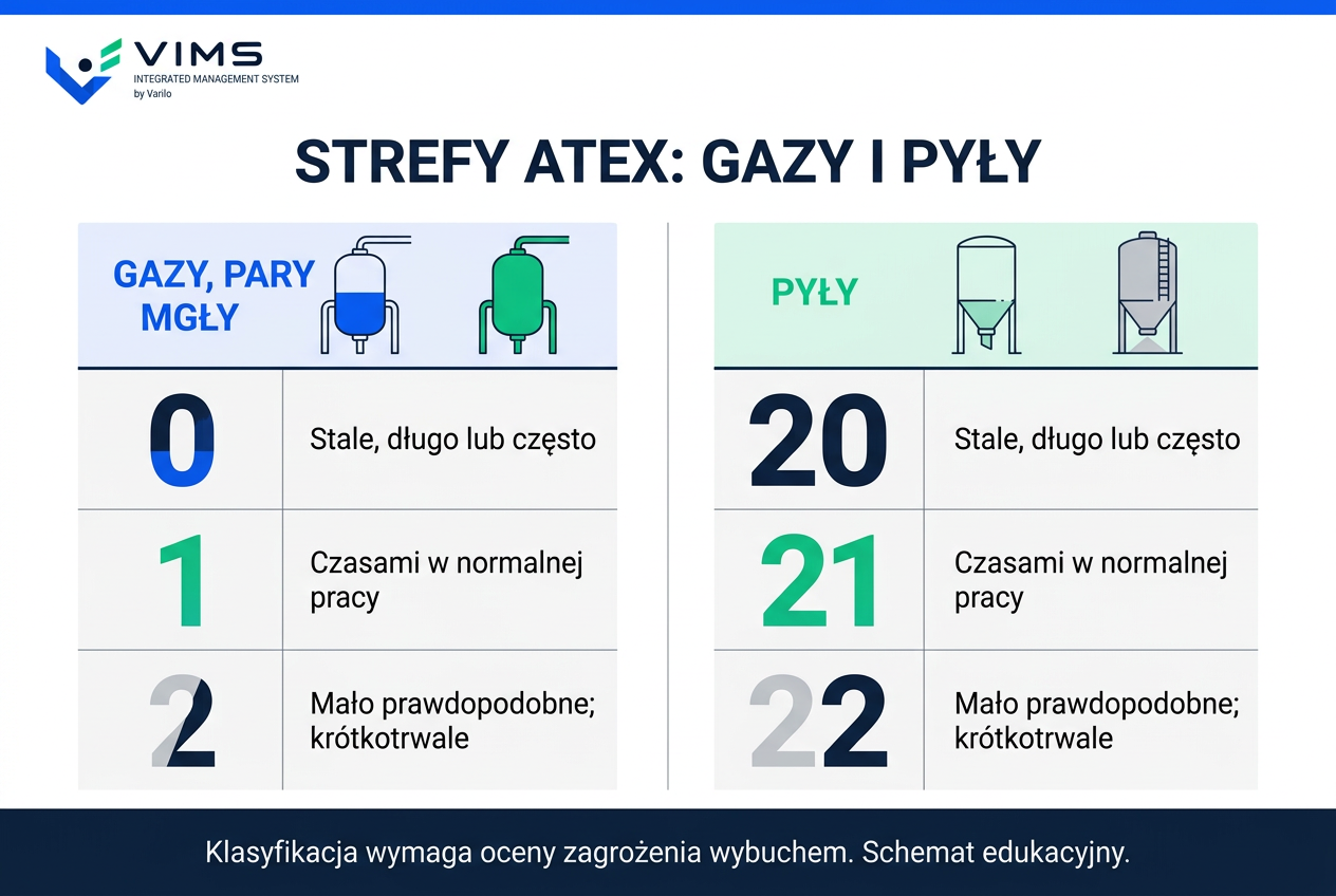
For gases, vapours and mists: zone 0 means an explosive atmosphere is present continuously, for long periods or frequently. Zone 1 means it is likely to occur occasionally in normal operation. Zone 2 means it is not likely in normal operation, but if it occurs it persists only briefly.

For a cloud of combustible dust in air the equivalent zones are 20, 21 and 22: continuous, long-lasting or frequent for 20; occasional in normal operation for 21; unlikely in normal operation and brief if it occurs for 22. Layers, deposits and heaps of combustible dust must also be considered as possible sources.

The zone number describes occurrence frequency and duration, not simply the severity of a possible explosion. Extent and height depend on releases, substances, ventilation and process conditions. There is no universal radius to draw around every vessel or silo.

Transfer the approved classification from the risk assessment and explosion protection document onto the map, with area identifiers and sources. Hot work, maintenance and contractor activities require the relevant procedures and PTW where specified. An ordinary smartphone is not automatically suitable for an Ex zone: put QR/NFC access outside it or use equipment properly selected for the zone and conditions.

ATEX classification chart comparing gas zones 0, 1, 2 and dust zones 20, 21, 22 by frequency of explosive atmosphere occurrence
Definitions, with Polish labels. The chart does not determine zone boundaries or replace an explosion risk assessment.

4. LOTO isolation points and chemical stores on one plan

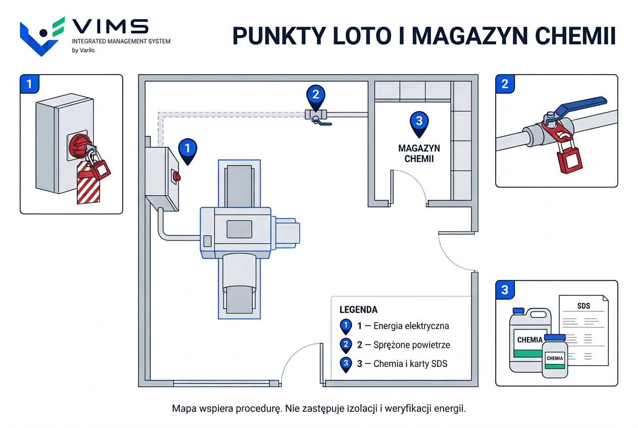
A LOTO map links the machine identifier to its actual energy-isolating devices: disconnectors, valves or other points specified by the procedure. Consider all relevant energy types, including electrical, pneumatic, hydraulic, mechanical, thermal and stored energy. A STOP button or emergency stop alone is not energy isolation.

The drawing helps locate a point and its instruction; it does not perform the lockout. Work still requires isolation, protection against re-energisation, release or restraint of residual energy and verification under the procedure. Identifiers on the plan, equipment and LOTO card must agree.

The chemical layer should show actual storage, SDS access, emergency equipment and storage restrictions. GHS pictograms come from the classification of the specific substance or mixture, not decorative labels for a whole store. Review relevant SDS information, including sections 5, 6, 7 and 10, for fire, release, handling and incompatible materials.

A shared location reference helps maintenance, EHS and quality. It does not make a chemical store an isolation point, or automatically assign every flammable substance a particular ATEX zone.

VIMS example map with electrical isolation point, compressed-air valve and chemical storage linked to safety data sheets
Polish-labelled example: 1 — electrical isolation, 2 — compressed air, 3 — chemical store. Lockout selection and use require an appropriate procedure.

5. From CAD or PDF to an interactive map: six steps

1) Collect a current floor plan and source documents: fire instructions, ATEX classification, explosion protection document, isolation procedures and chemical register. Check scale, orientation, room names and agreement with the site. Export CAD into a readable format supported by the chosen tool when needed.

2) Separate evacuation and fire protection, ATEX, energy and LOTO, chemicals and inspection layers. 3) Assign stable point identifiers and verify them on site; do not copy extinguisher and valve positions solely from an old file.

4) Link points to the correct instructions, SDS and responsibilities. 5) Establish who approves the content and what workers or contractors can see. Record the edition, review date and map owner; do not publicly expose confidential whole-site plans.

6) Test QR/NFC where it will be used and run a trial inspection. A report must identify a real area and a location someone can find. Keep accessible on-site instructions and arrangements for loss of network, power or phone access.

6. Keeping the map current when the site changes

Where an IBP is required in Poland, fire regulations require updating it at least every two years and after changes in building use or technological processes that affect fire safety conditions. This does not justify leaving an extinguisher in the wrong position on a map until the next scheduled review.

Do not automatically apply the same two-year interval to ATEX. Review the assessment and explosion protection document after significant changes to substances, ventilation, equipment or work organisation. The zoning may change even if the building walls do not.

Common problems include confusing fire compartments with Ex zones, unreadable legends, missing edition dates, overlooked residual energy, broken SDS links and whole-site access for every visitor. Check documents, physical labels and whether a person who did not create the map can locate its points.

7. How V-IMS Safety plans and zones supports site work

Safety plans and zones lets teams place areas and safety signs on a floor plan, link points to documentation and access plans in the field through QR/NFC. With the chemical module, locations can link to SDS; safety walks and reports identify defects in a particular place rather than vaguely near a production line.

Use the map for contractor briefings, fire equipment checks and preparing work requiring PTW. Visible information should match the role and area; connections depend on the modules in use. V-IMS organises access to approved data, but does not calculate fire-resistance classes for a designer or replace competent ATEX zoning assessment.

It is a shared tool for EHS, SHE/QHSE, engineering, quality and food safety. Start with one area's plans, then extend the connections to chemicals, inspections and corrective actions.

Paper plan versus interactive safety map

Paper documents can meet legal requirements. Digital mapping supports operations without removing engineering or organisational duties.

AreaPaper / static PDFInteractive map
UpdatesManual edits and replacement copiesUpdated data and controlled approved version
ReadabilityMultiple topics on one drawingLayers chosen for the task
DocumentationSeparate instruction and SDS binderLinks to relevant documents
InspectionsLocation described in a noteCheck point or report on the map
AccessDisplay case or printDigital access, e.g. QR/NFC, according to permissions
OutageNo network or battery neededNeeds contingency arrangements and available on-site documentation

Checklist before sharing a map

  • Fire and ATEX boundaries come from appropriate documentation, not guesswork.
  • Floor plans and equipment positions have been checked on site and the legend is readable.
  • LOTO points have consistent identifiers and the correct isolation procedures.
  • Chemical locations link to current SDS and actual hazards.
  • The map has an owner, review date and controlled sharing scope.
  • QR/NFC has been tested, including Ex equipment restrictions and network outage arrangements.

Frequently asked questions about safety plans and zones

Are fire compartments and ATEX zones the same?

No. A fire compartment limits fire spread through separation. An ATEX zone concerns the occurrence of an explosive atmosphere. Boundaries can overlap, but they come from different assessments and documents.

Who should update the site safety map?

The owner, manager or user carries responsibilities defined by applicable law and agreements. Competent professionals should prepare or verify technical content and classifications. Assign a map owner and approvers for individual layers.

Must ATEX zones be updated every two years?

There is no universal two-year interval for all ATEX classifications. Review the assessment and explosion protection document when significant changes affect explosion risk. The Polish two-year IBP update rule should not automatically be transferred to ATEX.

Does a digital map replace the fire safety instruction or posted evacuation plans?

No. It supports access and updates, but does not replace required instructions, technical documents, physical signs or plans. Establish the duties for the particular building and jurisdiction.

How should LOTO points be marked on a map?

Use identifiers consistent with physical labels and the isolation procedure. Show the energy type and actual isolation device. The map does not replace applying locks, managing residual energy or verifying the safe state.

Can a phone open the plan inside an Ex zone?

Do not take an ordinary phone into an Ex zone. Equipment must be properly selected and suitable for the zone and conditions. Alternatively, locate the access point and read the plan outside the zone.

See Safety plans and zones on your site's floor plan

In a demo, we will show how plans, documents, chemicals and inspections connect, with a scope suited to your team.